Introduction
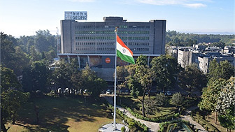
Geodata Processing and Interpretation Centre (GEOPIC) was established in 1987 at ONGC, Dehradun with a specific mandate of providing solutions to complex E&P problems by integrating seismic with other geo-scientific data.
The Centre has world class state-of-the-art infrastructure backed by G&G specialists in the field of seismic data processing, geo-scientific data interpretation, data management and supported by software and hardware engineers.
The strategic focus of GEOPIC pertaining to data processing and G&G data interpretation, R&D efforts (both In-house & Collaborative mainly) resulting in prospect generation and increasing the reserve base for the energy security of the nation GEOPIC is the largest computing facility of ONGC and one of the few centers around the world for integrated processing and interpretation of Geo-scientific data, from seismic to petrophysical, geological and reservoir engineering. Starting from a processing and interpretation center, the Institute has evolved and recognized as In-house R&D Unit by DSIR, GoI since 2011. The QMS of GEOPIC is certified with ISO 9001:2015 and ISMS is certified with ISO27001.
Since inception GEOPIC on one hand, has made giant strides, putting in place, world class facilities, and infrastructure, while upgrading existing technologies and assimilating newer technologies in line with best in the industry. On the other hand, the focus is on creating and nurturing specialist teams and domain experts in various areas of Exploration and Development activities. Recently dedicated groups for AI-ML based solutions and Reservoir Simulation have been created at GEOPIC. Disseminating the skill sets and knowledge to the newer generation of geoscientists is yet another priority area. All these efforts will cumulatively contribute towards creating an optimal environment for delivering the best possible solutions.
Capabilities
- Seismic Data Processing and Interpretation: GEOPIC has advanced capabilities in seismic data processing and interpretation, utilizing AI and machine learning workflows to add significant value to projects.
- In-House Developed Tools: GEOPIC has created innovative tools like Seistelligence for AI-driven seismic analysis, SeisLytics for unsupervised machine learning on seismic attributes, and WellLytics for clustering and interpreting well logs.
- Integration of Advanced Technologies: GEOPIC continuously evaluates and integrates cutting-edge technologies such as PP-PS joint inversion, Sparse Layer Inversion (SLI), and Litho-Petro-Elastic (LPE) inversion to enhance exploration and production processes.
- Collaborative Research and Development: GEOPIC engages in collaborative R&D projects with prestigious institutions and consortia, such as the joint inversion of seismic and potential field data and the development of advanced seismic imaging software.
- Machine Learning and Automation: GEOPIC focuses on automating complex processes and developing new workflows for improved seismic data interpretation using machine learning and deep learning techniques.
- Pioneering New Techniques: GEOPIC leads the way in pioneering new geophysical techniques.
Highlights of FY 2023-24
GEOPIC completed 38 Scheduled G&G Interpretation projects and 21 Scheduled processing projects under AWP 2023-24. Total 24 Unscheduled projects (10 G&G interpretation projects & 14 processing projects) were completed.
Significant Projects
- ES360 PSDM of VN-ONHP-2019/2, Depth processing for better imaging of Rohtas, Mohana Fawn (Limestone), Jardepahar & Kajarhat area.
- To establish Joint Refraction and Reflection Travel time Tomography on a 3D land data (R&D)
- Reservoir Characterization of Oligocene Sands in B-12/C-26 area through pre-stack inversion (R&D)
- Geological Model and Pore Pressure Modelling of Mio-Pliocene Sands in Mahanadi Basin
- Play Consolidation of Mid. Eocene to Early Oligocene plays in NW Mukta Area
- International Project: Completed an integrated processing and interpretation project for GPOC, South Sudan, earning 1.2 million USD in revenue.
- Simulation Study: Conducted a simulation study for early monetization of the unconventional Jardepahar reservoir, Hatta Field, Madhya Pradesh; GEOPIC is the principal partner for the Field Development Plan.
- Production Enhancement Strategy: Prepared a strategy for production enhancement in the Bassein pay of Neelam field through immiscible crestal gas cap gas injection and optimization of water injection.
Collaborative projects/Joint Research projects/ MOUs
- 3 MoUs are active presently at GEOPIC, one with BHU, Varanasi, another one with WIHG, Dehradun, and the third one with Rezylytics.
Technology Induction/Absorption
- Seistelligence: AI tool for predicting logs, seismic and reservoir properties, and automated well-to-seismic calibration and fault prediction.
- SeisLytics: Python-based unsupervised machine learning software for seismic attribute analysis and clustering.
- WellLytics: Software for well log integration and clustering using eight unsupervised machine learning algorithms.
- PP-PS joint inversion PoC with Beicip-Franlab: Evaluation of the InterWell module, approval in progress.
- Paleoscan: New-generation seismic interpretation software, induction in progress.
- Sparse Layer Inversion (SLI) from M/s- Lumina: Thin layer delineation technology, approval in progress.
- Litho-Petro-Elastic (LPE) inversion PoC with Schlumberger: Evaluation completed.
- Joint inversion of seismic & potential field data in Baola area of WON: Collaborative project with BHU.
- SeisRTM software development at C-DAC, Pune: RTM package for 2D & 3D seismic data imaging under National Super Computing Mission.
- Automating Stacking Velocity Analysis using Machine Learning: In-house R&D initiative, NMO tracking model built and tested.
- Joint Refraction and Reflection Traveltime Tomography: Workflow for near-surface model to depth velocity model building.
- PSDM (ES360) and Fracture characterization through AVAz and VVAz: Applied in Cauvery Basin & Vindhyan Basin.
- AASPI consortium tool: Used for seismic-based multi-attribute and AI/ML-based studies in four areas.
Papers Published / Presented
The institute published/presented 24 technical papers in national/international - journals/conferences in 2023-24.
IPRs / Patents / Copyrights / Trademarks
The institute holds 8 copyrights as on 31st March 2024. The following are the details for FY 23-24:
Copyrights obtained: 2
- Discontinuity Tracker” and “SeisLytics”, both being Python based AI-ML Softwares with specific purposes.

